The 1885 Atlantic hurricane season ran through the summer and the first half of fall in 1885. This is the period of each year when most tropical cyclones form in the Atlantic basin. In 1885 there were two tropical storms and six hurricanes in the Atlantic basin. However, in the absence of modern satellite monitoring and remote-sensing technologies, only storms that affected populated land areas or encountered ships at sea were recorded, so the actual total could be higher. An undercount bias of zero to six tropical cyclones per year between 1851 and 1885 and zero to four per year between 1886 and 1910 has been estimated.[1]
Season summary
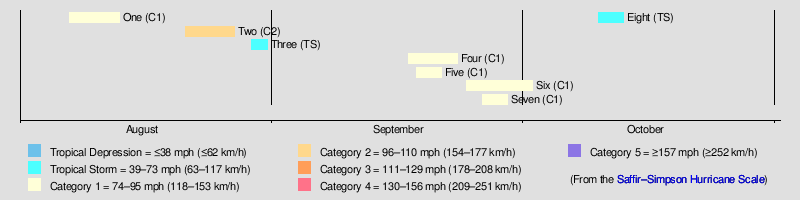
The Atlantic hurricane database (HURDAT)[2] recognizes eight tropical cyclones for 1885 in the Atlantic basin; two were tropical storms and six were hurricanes. The most significant storm of the season was Hurricane Two, which hit Georgia as a Category 2 hurricane, causing 25 deaths. The first cyclone was a tropical storm that existed in the Atlantic between August 7 and August 13 without making landfall. From north of Puerto Rico, Hurricane Two struck the Bahamas but then remained offshore until making a landfall in South Carolina. The hurricane caused considerable damage throughout the Carolinas, Georgia and Maryland. Also in August, Tropical Storm Three formed in the Gulf of Mexico, before crossing Florida and dissipating off South Carolina. Hurricane Four also grew from a tropical storm that formed in the Gulf of Mexico. It brought high winds and flooding to towns along the Gulf coast. This storm also crossed over Florida into the Atlantic and eventually made another landfall at New Brunswick as an extratropical storm. Hurricane Five existed in the tropical Atlantic between September 18 and September 21, without making landfall. Hurricane Six formed as a tropical storm in the Gulf of Mexico and reached hurricane strength off North Carolina a week later on October 2. The cyclone had impacted both Mississippi and Florida as it had travelled north. Hurricane Seven existed in the mid-Atlantic between September 26 and September 29. The last known cyclone of 1885 was Tropical Storm Eight which formed north of Cuba and impacted Florida. It travelled through the south-east United States and brought gales and flooding to the North Carolina coast.
A tropical storm was seen on August 7 to the southeast of Bermuda. It moved north-northeastward, and became a hurricane on August 8. It turned to the northeast, and passed offshore of Newfoundland on the 10th as a 90 mph (145 km/h) hurricane. The hurricane weakened over the north Atlantic Ocean, and became extratropical on the 14th.[2]
Although observations prior to August 23 could not be located,[3] HURDAT begins the track of this storm approximately 185 mi (300 km) north of Puerto Rico on August 21,[4] based on a 1993 reanalysis led by C. J. Neumann.[3] The tropical storm moved generally westward and crossed the southern Bahamas, until curving north-northwestward while passing just west of Andros between August 22 and August 23. After intensifying into a hurricane early on August 24, the cyclone passed very close to Florida, including just over 10 mi (15 km) east of Jupiter Island at 06:00 UTC. The storm then curved northeastward early the next day, hours prior to making landfall on Kiawah Island, South Carolina. Based on a pressure observation of 974 mbar (28.8 inHg), the cyclone was likely a Category 2 hurricane with winds of 105 mph (165 km/h). The hurricane passed across North Carolina just west of Wilmington and Hatteras, near where it re-emerged into the Atlantic early on August 26. Although the storm weakened to a Category 1 hurricane, it re-intensified into a 105 mph (165 km/h) Category 2 hurricane,[4] based on the bark Harold recording a barometric pressure of 958 mbar (28.3 inHg).[5] Late on August 27, the system transitioned into an extratropical cyclone about 290 mi (470 km) east of Newfoundland, and continued northeastward until dissipating late the next day.[4]
In Florida, abnormally high tides and "high winds pummeled the coast" according to Jay Barnes,[6] with a sustained wind speed of 60 mph (95 km/h) and hurricane-force wind gusts in Jacksonville.[7] Nearby, winds destroyed a hotel, while many buildings and boats suffered significant damage in Fernandina Beach.[8] The storm disrupted attempts to settle present-day Cocoa Beach, with waves flooding many homesteads. Nearby, severe erosion occurred in the vicinity of the Cape Canaveral Lighthouse, prompting an effort to move the lighthouse about 1 mi (1.6 km) farther inland.[6] Sustained winds in Georgia reached 56 mph (90 km/h) on Tybee Island.[7] About $1.69 million in damage occurred in Charleston, South Carolina. In North Carolina, an anemometer at Smithville (modern-day Southport) measured a 5-minute sustained wind speed of 98 mph (158 km/h) before being destroyed. The storm caused considerable damage at Wilmington, Smithville, and Morehead City. The value of this damage was estimated at $100,000.[9] Heavy rains and flooding were also seen across Maryland. At Ellicott City, lightning set fire to a residence, causing about $16,000 in damage.[10] In total, the hurricane caused 25 deaths,[11] with 21 of those occurring in South Carolina.[12]
Tropical Storm Three
Tropical storm (SSHWS)
Duration
August 29 – August 31
Peak intensity
60 mph (95 km/h) (1-min);
A tropical storm formed in the western Gulf of Mexico on August 29. It moved quickly to the northeast, and made landfall on extreme southeastern Louisiana on the 30th as a 60 mph (97 km/h) tropical storm. After crossing Florida, the storm was last seen off the coast of South Carolina on August 31.[2]
On September 17, a tropical storm developed in the western Gulf of Mexico near Veracruz, Mexico. It paralleled the Gulf of Mexico coastline to the northeast flooding coastal towns. Winds along the Texas coast at Indianola were reported at 45 miles per hour (72 km/h). After hitting southeastern Louisiana on September 21, the storm crossed Florida. Over the Western Atlantic, it strengthened to become a hurricane on the 22nd before becoming extratropical near its New Brunswick landfall on the 23rd. The storm brought flooding to Indianola and coastal flooding in the Galveston area. Four people died when a coal barge, the Orient, was cast adrift in the Gulf.[13]
From September 18 to the 21st, a hurricane existed in the tropical Atlantic Ocean to the northeast of the Lesser Antilles, peaking at 80 mph (129 km/h) before never being seen again.[2]
Hurricane Six
Category 1 hurricane (SSHWS)
Duration
September 24 – October 2
Peak intensity
80 mph (130 km/h) (1-min);
A tropical storm formed in the central Gulf of Mexico on September 24. It drifted northward, and hit southeastern Mississippi before turning eastward. It moved across the Florida panhandle and peninsula, and became a hurricane to the southeast of North Carolina on October 2. Its track after this point is unknown.[2] Climate researcher Michael Chenoweth's 2014 study argued that the Gulf of Mexico portion of the track of this storm should deleted from HURDAT and the remaining path to be reclassified as extratropical.[14]
A tropical storm in the central Atlantic Ocean moved northward in late September, steadily strengthening and eventually reached 90 mph (145 km/h) winds. The storm was last recorded to the south of Nova Scotia and east of New England on September 29th.[2] The storm peaked with winds of 90 mph (145 km/h) and a central pressure of 982 mbar (hPa)
A tropical storm formed north of Cuba on October 10. It moved northward, and hit Florida as a strong tropical storm. It moved northeastward through the southeast United States, passing west of Jacksonville and later Savannah. It reached southwestern Virginia around midnight on October 12 and became extratropical on the 13th. Gales of 44-56 mph occurred along the North Carolina coast. High tides coincided with the storms passage and led to the waterfront at Smithville (Southport) being flooded.[9]
Other storms
Chenoweth proposed three other storms not currently listed in HURDAT:[14]
October 7 to October 18, peaked as a tropical storm
October 18 to October 27, peaked as a tropical storm
November 8 to November 10, peaked as a tropical storm
^Landsea, C. W. (2004). "The Atlantic hurricane database re-analysis project: Documentation for the 1851–1910 alterations and additions to the HURDAT database". In Murname, R. J.; Liu, K.-B. (eds.). Hurricanes and Typhoons: Past, Present and Future. New York: Columbia University Press. pp. 177–221. ISBN0-231-12388-4.
^ abcdefHurricane Research Division (2012). "Easy to Read HURDAT". National Oceanic and Atmospheric Administration. Retrieved October 23, 2012.
^Roth David M.; Cobb, Hugh (July 16, 2001). "Virginia Hurricane History". National Oceanic and Atmospheric Administration. Archived from the original on January 8, 2008. Retrieved October 2, 2024.