The 45×90 points are the four points on Earth which are both halfway between one of the geographical poles and the equator, and halfway between the Prime Meridian and the 180th meridian. Both northern 45×90 points are located on land, while both southern 45×90 points are in remote open ocean locations.
45°N, 90°W
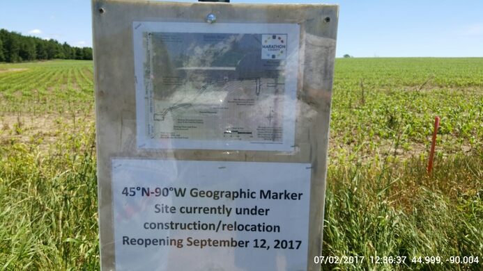
The original marker for the 45×90 point in North America; the sign was later amended to explain that a marker had been placed on the real location, approximately 324 m (1,063 ft) away.
The former marker has been replaced by a small parking lot with a trail that leads to a long, rectangular park. The Geographical Marker is at the southern end of the park along with informational displays.
The point has become something of a pop culture phenomenon thanks to Gesicki's Tavern in the tiny cluster of establishments in Poniatowski.[3] They sold 45×90 T-shirts and registered visitors as members of the "45×90 Club".[3] Since 2006, the Wausau/Central Wisconsin Convention & Visitors Bureau has been the holder of the official "45×90 Club" registration book. The book is on loan from the family.[4] On becoming a member of the club, the Bureau gives a commemorative coin.
Image of the current 45Nx90W marker in Marathon County, Wisconsin, United States
Image of the larger context for the 45Nx90W marker in Marathon County, Wisconsin, United States
Image of 45Nx90W geographical marker informational display.
45°N, 90°E
The only other 45×90 point located on land is 45°0′0″N90°0′0″E / 45.00000°N 90.00000°E / 45.00000; 90.00000, which is at an elevation of 1,009 m (3,311 ft) above sea level. This point is located in a desolate region of the Xinjiang Uyghur Autonomous Region of China, near the Mongolian border, approximately 240 km (150 mi) northeast of Ürümqi. Administratively, it is on the border of Qitai and Qinggil counties. Greg Michaels, an American, and Ru Rong Zhao, a taxi driver from the closest town of Qitai, which is 110 km to the south-southwest, visited this point on April 13, 2004 and documented the visit on the Degree Confluence Project.[5] Their visit found no monument or any physical recognition of the status and documented that the nearest community to the site documented on maps, Jiangjunmiao, had long since been abandoned.
45°S, 90°E
The search for Malaysia Airlines Flight 370 was near the coordinate 45°S, 90°E. The coordinate is closest to the red dot labeled as Gaofen 1 at the bottom, halfway between the center and left side of the image.
In March 2014, the point was in one of a few strips in a search for the missing Malaysia Airlines Flight 370, after potential debris were spotted by satellite about there.[6][7]
Each 45×90 point is the antipode – the point on the opposite side of Earth – of another 45×90 point.
The southern Indian Ocean location and the point in Wisconsin are antipodes of each other. The southern Pacific Ocean location and the point in China are antipodes of each other.
.svg)

.jpg)


