County in Yeongnam, South Korea
Goryeong
고령군 |
|---|
|
|
| • Hangul | 고령군 |
|---|
| • Hanja | 高靈郡 |
|---|
| • Revised Romanization | Goryeong-gun |
|---|
| • McCune-Reischauer | Koryŏng-gun |
|---|
 Flag  Emblem of Goryeong |
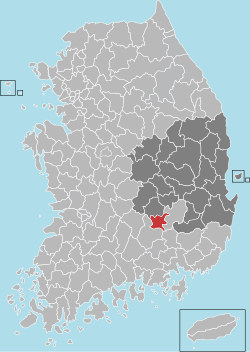 Location in South Korea |
| Country |  South Korea South Korea |
|---|
| Region | Yeongnam |
|---|
| Administrative divisions | 1 eup, 7 myeon |
|---|
|
| • Total | 383.7 km2 (148.1 sq mi) |
|---|
|
| • Total | 35,000 |
|---|
| • Density | 91.2/km2 (236/sq mi) |
|---|
| • Dialect | Gyeongsang |
|---|
Goryeong County (Korean: 고령군; RR: Goryeong-gun) is a county in North Gyeongsang Province, South Korea.
Goryeong is a historical center of the ancient kingdom of Daegaya.
Administrative divisions
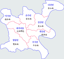 Map of Goryeong County in Korean
Goryeong County is divided into 1 eup and 7 myeon.
| Name
|
Hangeul
|
Hanja
|
| Daegaya-eup
|
대가야읍
|
大伽倻邑
|
| Deokgok-myeon
|
덕곡면
|
德谷面
|
| Unsu-myeon
|
운수면
|
雲水面
|
| Seongsan-myeon
|
성산면
|
星山面
|
| Dasan-myeon
|
다산면
|
茶山面
|
| Gaejin-myeon
|
개진면
|
開津面
|
| Ugok-myeon
|
우곡면
|
牛谷面
|
| Ssangnim-myeon
|
쌍림면
|
雙林面
|
Climate
Goryeong has a humid continental climate (Köppen: Dwa), but can be considered a borderline humid subtropical climate (Köppen: Cwa) using the −3 °C (27 °F) isotherm.
| Climate data for Goryeong (1993–2020 normals)
|
| Month
|
Jan
|
Feb
|
Mar
|
Apr
|
May
|
Jun
|
Jul
|
Aug
|
Sep
|
Oct
|
Nov
|
Dec
|
Year
|
| Mean daily maximum °C (°F)
|
6.4
(43.5)
|
9.2
(48.6)
|
14.7
(58.5)
|
20.6
(69.1)
|
25.6
(78.1)
|
28.3
(82.9)
|
30.0
(86.0)
|
30.9
(87.6)
|
26.7
(80.1)
|
21.8
(71.2)
|
15.0
(59.0)
|
8.1
(46.6)
|
19.8
(67.6)
|
| Daily mean °C (°F)
|
−1.1
(30.0)
|
1.7
(35.1)
|
6.9
(44.4)
|
13.0
(55.4)
|
18.1
(64.6)
|
22.2
(72.0)
|
25.2
(77.4)
|
25.6
(78.1)
|
20.6
(69.1)
|
13.9
(57.0)
|
7.2
(45.0)
|
0.6
(33.1)
|
12.8
(55.0)
|
| Mean daily minimum °C (°F)
|
−7.4
(18.7)
|
−5.1
(22.8)
|
−0.4
(31.3)
|
5.4
(41.7)
|
11.1
(52.0)
|
16.8
(62.2)
|
21.4
(70.5)
|
21.6
(70.9)
|
16.0
(60.8)
|
8.0
(46.4)
|
0.8
(33.4)
|
−5.4
(22.3)
|
6.9
(44.4)
|
| Average precipitation mm (inches)
|
18.0
(0.71)
|
30.2
(1.19)
|
47.1
(1.85)
|
83.9
(3.30)
|
93.6
(3.69)
|
144.3
(5.68)
|
259.8
(10.23)
|
283.4
(11.16)
|
161.4
(6.35)
|
65.0
(2.56)
|
30.3
(1.19)
|
18.4
(0.72)
|
1,235.4
(48.64)
|
| Average precipitation days (≥ 0.1 mm)
|
2.9
|
3.5
|
5.6
|
7.9
|
8.0
|
8.4
|
13.2
|
12.7
|
8.6
|
4.4
|
4.5
|
3.0
|
82.7
|
| Source: Korea Meteorological Administration[1]
|
Twin towns – sister cities
Goryeong is twinned with:
See also
References
External links
35°43′49″N 128°16′08″E / 35.7302777878°N 128.268888899°E / 35.7302777878; 128.268888899


