It is located on the northeastern slopes of the Elm hill range, within the Elm-Lappwald Nature Park, about 23 km (14 mi) east of Brunswick, 15 km (9.3 mi) west of the district capital Helmstedt, and 20 km (12 mi) south of Wolfsburg.
The town has access to the Brunswick–Magdeburg railway at the Königslutter railway station, served by Regionalbahn trains to Brunswick and Helmstedt, and is traversed by the Bundesstraße 1 federal highway. The Bundesautobahn 2 runs about 6 km (3.7 mi) north of the town centre. Königslutter is a stop on the German Timber-Frame Road (Deutsche Fachwerkstraße) tourist route.
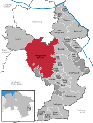
In its current form, the township with about 16,000 inhabitants was created in a 1974 administrative reform by joining the following 18 municipalities:
A water castle was erected around 1200 and in 1318 the surrounding settlement was documented as a market town. Around 1400 the Dukes of Brunswick granted the citizens of Lutteretown privileges. From the late 14th century onwards, the place was called Konnigesluttere, referring to late Emperor Lothair III, King of the Romans.
Located on the trade route from Brunswick to Magdeburg (the present-day Bundesstraße 1), beer brewing and Elm limestone mining and cutting were its main industries in early modern times, while the monastery developed as a pilgrimage destination. Not until 1924, the monastery complex and the adjacent settlement of Oberlutter were incorporated into the town. The monastery church is known for its sculptural art and the tomb of the emperor.
Politics
St Sebastian Church and town hall
Seats in the town's assembly (Rat) as of 2011 local elections: