Marawi, officially the Islamic City of Marawi (Maranao: Bandar a Marawi; Filipino: Lungsod ng Marawi), is a 4th class component city and capital of the province of Lanao del Sur, Philippines. According to the 2020 census, it has a population of 207,010 people.[4]
Marawi is located upon the shores of Lake Lanao.[6] It is primarily inhabited by the Maranao people. The city is also called the "Summer Capital of the South" due to its higher elevation and cooler climate,[7][failed verification] a nickname it shares with Malaybalay.[8][better source needed]
On May 23, 2017, the city suffered extensive damage during the Battle of Marawi as militants affiliated with the Islamic State invaded the city and engaged in a massive urban gunfight.[9] The ensuing battle lasted until October 23, 2017, when Defense Secretary Delfin Lorenzana announced the ending of the battle. Major damage of the city was mostly caused by airstrikes carried out by the Philippine Air Force in an attempt to eliminate the militants.
Etymology
Dansalan (Marawi's prior name) derived from the Mëranaw word "dansal", which means rendezvous; literally, it also means arrival[10] (in other source,[11] "where the waves come to shore"). Being known as the destination point for arriving boats,[11] the place refers to a port,[12] hence, the "Place of Destination and Purpose."[13]
Meanwhile, Marawi is derived from the word "rawi", which means reclining, in reference to Agus River.[10] On the other hand, this present name is in honor of the city's martyred hero in Kuta Maraghui (Fortress of Marawi) in 1895.[11]
Around the original Meranaw fortification, Spanish captain Francisco Atienza founded a settlement called Dansalan in October 1639. His forces had come from Iligan and were attempting to conquer the entire Lake Lanao area. However, it was abandoned later the same year when thousands of Meranaw soldiers invested the then-fortifying settlement, pressing the Spaniards hard and thus they returned to Iligan, having failed in their quest.[12]
The Spaniards only returned to the area when they began the conquest of the Sultanate of Maguindanao in the 19th century.[12] They made attempts to capture Marahui, the stronghold of the Maranao, twice until they succeeded in 1895 with the deaths of Datu Amai Pakpak and Datu Sinal.[14] They abandoned the place again upon the arrival of the Americans in the country in 1898.[12][14]
Dansalan was created as a municipality by the Moro Province legislative council on May 24, 1907;[13][15] served as the capital of the undivided Lanao province since its declaration by the American Colonial Government.[10][11]
A sovereign of Marawi before 1639 was "Datu Buadi Sa Kayo" who imposed taxation.[citation needed]
Cityhood (1940), renaming as Marawi (1956), and later developments
Skyline of Marawi in 2008
Dansalan was the last to become a chartered city under the country's Commonwealth era with the approval of Commonwealth Act No. 592 on August 19, 1940.[11][17] During World War II, the Japanese invaded Dansalan and established a "comfort station" in the city, where local girls, teenagers, and young adults were kidnapped and turned into sex slaves under brutal "comfort women" system, where victims were routinely gang-raped and killed by Japanese soldiers.[18][19][20] After the Second World War, inauguration took place on September 30, 1950.[21] It was renamed Marawi City on June 16, 1956 through Republic Act (RA) No. 1552 which amended the charter.[11][22][10][13]
Upon division of Lanao province through RA No. 2228 in 1959, it was made capital of Lanao del Sur.[11][23]
The city, being the country's only predominantly Muslim chartered city, was declared "Islamic City of Marawi" through City Council Resolution No. 19-A on April 15, 1980.[10][11][13] This was proposed by Parliamentary Bill No. 261 in the defunct Batasang Pambansa, the country's former parliament during the Marcos regime, reportedly to attract funds from the Middle East.[7]
On May 23, 2017, a pro–Islamic State of Iraq and the Levant group called the Maute group attacked the city. The battle of Marawi—also known as the Marawi siege, the Marawi clash, and the Marawi crisis—started on May 23. CNN Philippines reported that the militants had over 500 men.[24] Philippine President Rodrigo Duterte declared martial law on the island of Mindanao, where the fighting was taking place, initially until December 31, 2017,[25] but was later extended to the end of 2018 and then again to the end of 2019.[25][26] The city was liberated from militant control on October 17, 2017 and battle operations officially ended on October 23, 2017.
The plebiscite for the creation of two barangays on March 18, 2023, marking the first exclusively local electoral exercise in the city post-siege,[28] was held in five polling precincts.[34] With 96.88% of registered voters participated, majority of them later ratified the proposal.[35][32] The creation became effective, months prior to the Barangay and Sangguniang Kabataan elections in October.[36][37]
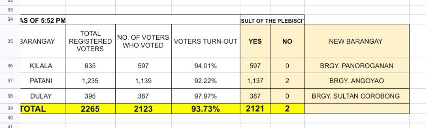
Another plebiscite, seeking for the creation of three additional barangays, was held on March 9, 2024,[31] in eight clustered precincts.[38] With 93.73% voter turnout, the proposal was ratified, almost unanimously.[39][40]
Geography
Lake Lanao viewed from Marawi
Marawi has a total land area of 8,755 hectares (21,630 acres).[41] It is located on the northernmost shores of Lake Lanao and straddles the area where the Agus River starts. It is bounded to the north by the municipalities of Kapai and Saguiaran; to the south by Lake Lanao; to the east by the municipalities of Bubong and Ditsaan-Ramain; and to the west by the municipalities of Marantao and Saguiaran.[7] The Bagang beach is situated 2 kilometers (1.2 mi) from the city's commercial center.
The Muslim majority city also hosts a national park, the Sacred Mountain National Park, which spans the barangays of Guimba and Papandayan covering an area of 94-hectare (230-acre). The protected area was established on August 5, 1965, by Republic Act no. 4190.[42] The park is dominated by Mount Mupo, a 900-foot (270 m) tall[43] extinct volcanic cone. The park is ideal for birdwatching and mountain climbing to the summit that features a small pond.[44][better source needed]
Topography
Mountains, rolling hills, valleys, and a large placid lake dominate the city's landscape. Angoyao Hills (Barangay Sogod) served as natural viewpoint over the water of the Lake Lanao. Signal Hill (Barangay Matampay), Arumpac Hill (Barangay Saduc), and Mt. Mupo (Barangay Guimba) are considered beautiful but mysterious. Mt. Mupo, located within the Sacred Mountain National Park, is known for its untouched trees and beautiful, perfect cone.[citation needed]
Marawi's weather is warm and wet throughout the year. With the elevation along Lake Lanao at around 2,300 feet (700 m),[3] this raised altitude together frequent heavy showers at all seasons, ensures that hot conditions are seldom observed.
The economy of Marawi is largely based on agriculture, trading, and exporting. Most industries in the city are agriculture-oriented. They include rice and corn farming, hollow blocks manufacturing, goldsmithing, and saw milling. Small and cottage-size enterprises are engaged in garment making, mat and malong weaving, wood carving, brassware making, web development, and blacksmithing.[7]
Apart from that, Marawi is home to NPC – Agus 1 Hydro Electric Power Plant and the first of the six cascading Agus Hydro Power Plants.
A new wind and solar energy plant and a new diesel-generated power plant are set to be developed in Saguiaran, Lanao del Sur, by two private firms to provide electricity to Marawi and adjoining areas.[59][60][better source needed] The project will cost PHP 2 billion and will generate 10 to 30 megawatts of electricity.[59]
This section is empty. You can help by adding to it. (March 2021)
Architecture
The feeling of the unique natural setting of the Maranaos in Marawi is manifested by the presence of many large Torogans, an antique royal high-roofed houses with carvings designed by the Meranau, and the Sambitory Old Building in Barrio Naga in front of Tuaka Laput, Marawi.
Marawi is home to the main campus of Mindanao State University, the biggest state university in Philippines. Other institutions and colleges are well established in the city and are as follows:
Mindanao State University – Lanao National College of Arts and Trade
Philippines Engineering and Agro-Industrial College
Lanao Central College
Khadijah Mohammad Islamic Academy
Masiricampo Abantas Memorial Educational Center, Inc.
Philippine Integrated College Academy Foundation Inc.
Other notable secondary schools are:
Mindanao State University – Institute of Science Education- Science High School
Mindanao State University – Integrated Laboratory School
Mindanao State University – University Training Center
Ibn Siena Integrated School Foundation
Hadiyyah International School
Dansalan College Foundation Inc.
Dhayfullah Islamic Institute, Inc.
Philippine Integrated School
Al-Khwarizmi International College – Science Laboratory High School
Marawi City National High School
Dansalan National High School
Aba Al-khail Computer School
Masiricampo Abantas Memorial Islamic and Science Academy
TESDA is also stationed in Marawi which caters to technical training of students for the province.
Within the Mindanao State University is the Aga Khan Museum of Islamic Arts which is named in honor of SultanAga Khan who contributed to the realization of the museum. Historical development of the country is bank on the large space upon the conservation of cultural materials. It has huge, collection of indigenous art, displayed ethnic music tape recorded, the native folk dances from different regions of Mindanao, Sulu and Palawan, the native tools and weapons used by the Muslims and different artistic designs of houses are the main attractions of museum. Indigenous art and cultural material are being displayed.


.svg)

.jpg)


.jpg)
.jpg)
.jpg)
.jpg)
.jpg)
.jpg)


