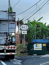
Highway in Puerto Rico
Puerto Rico Highway 863 (PR-863) is a road located in the municipality of Toa Baja in Puerto Rico. With a length of 2.5 kilometers (1.6 mi), it begins at its intersection with PR-2 in Candelaria barrio and ends at its junction with PR-862 on the Toa Baja–Toa Alta–Bayamón municipal tripoint.[2]
Route description
This highway has a single lane per direction in the entire length and provides access to several communities and neighborhood developments between Candelaria, Mucarabones and Hato Tejas barrios.[3] Located within Candelaria barrio, PR-863 extends to the south from PR-2 junction to PR-819 intersection. Then, it turns to the southeast through southeastern Candelaria until its terminus at PR-862 junction on the Toa Baja's southernmost point.[4]
-
PR-2 west at PR-863 intersection in Candelaria barrio
-
Signs for PR-2 at the western terminus of PR-863 in Candelaria barrio
-
Northern terminus of PR-819 at PR-863 junction in Candelaria barrio
History
Prior to its numerical designation, PR-863 was only known as Camino Frailes.[5] The current numerical designation corresponds to the 1953 Puerto Rico highway renumbering, a process implemented by the Puerto Rico Department of Transportation and Public Works (Spanish: Departamento de Transportación y Obras Públicas) that increased the insular highway network to connect existing routes with different locations around Puerto Rico.
Major intersections
See also
References
External links


